A (somewhat) Brief History of the Green Line
The Green Line is the biggest infrastructure project in Calgary’s history and as such, it has also been the single-most engaged project in Calgary’s history. That engagement happened a little while ago now, perhaps an eternity ago in some people’s minds and has led to some forgetting some key details. There’s even been some rumblings that the estimated price tag is something I had pulled out of a hat, despite there being numerous reports from Administration presented to Council providing the cost estimates for the entire Green Line dating back to 2013. Estimates for the southeast portion were provided to Council before that in 2012 – more on that later.
We engaged on the Green Line, with meaningful, intensive engagement with communities, businesses, and individuals alike over approximately 6 years . Ultimately, as a result of that engagement, an alignment to the north along Centre Street and an alignment to the South, going through the Beltline, Inglewood, Ramsay and Highfield, before going down 24 th Street and jogging over to 52 nd Street was decided on. But before all that, we were just talking about a southeast transitway.
How did we get to a Green Line from a transitway? Part of that had to do with me sticking my neck out in 2013, and part of it had to do with the support from federal partners such as Michelle Rempel, and then federal-cabinet minister, now Alberta Premier, Jason Kenney.
But the Green Line truly goes back further than that. If you look on the City’s website, there is Green Line timeline outlining the majority of the steps that have brought us to today. The timeline indicates that in 1983, the idea of a Southeast LRT line is born. While I don’t have a reference for that, the City conducted an internal study in 1987. That study concluded that SE Calgary would one day require a dedicated LRT line. After that 1987 study, the alignment began being planned in segments, with land being acquired as part of new community planning in southeast Calgary. In the McKenzie East Area Structure Plan (ASP), approved in 1986 (even before the previously mentioned 1987 study!), which included the communities of McKenzie Towne, New Brighton and Copperfield, land was set aside along 52 nd Street for an eventual LRT line. The ASP specifically accounted for two future LRT stations located within East McKenzie, which we now know as Prestwick Station and McKenzie Towne Station. You can find the ASPs if you’re curious on the Planning & Development resource library page of the City’s website, and then open up “Planning policies” and “Local policies”. Alternatively, here is the direct download link for the McKenzie East ASP .
Moving forward, a number of functional planning studies for the southeast LRT were completed, starting in 1999 going from Glenmore Trail south to 107 th avenue, continuing on until 2010, as you can see below. The table is from the 2010 Southeast LRT: Compendium of Functional Planning Studies .
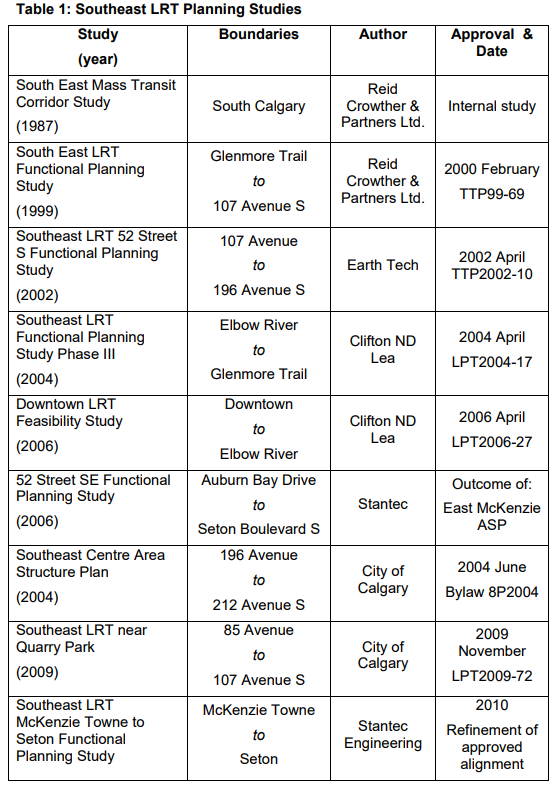
In the above referenced 2010 Southeast LRT Compendium , it stated that the southeast LRT will eventually replace the BRT service based on ridership growth and funding. The real kicker is that it states that “ It is anticipated that the Southeast LRT will be required before Calgary’s population reaches 1.25 million .” Calgary hit that mark in 2015 .
In 2011, the City submitted a Phase I GreenTRIP application to the Province, in support of a number of transit initiatives, including a SE LRT/SE BRT and transit-oriented development land use plan for the SE Transitway. The SE LRT was “ identified as the next priority in the construction of the six lines of Calgary’s LRT network .” Council was also asked to “ direct Administration to reaffirm Council’s commitment to a SE LRT by way of preparing a report detailing a plan of action to move forward on a SE Transitway (SETWAY) that would be the precursor to a true SE LRT.” The GreenTRIP application was formally made later that year. The SETWAY proposal built steam, was discussed by Committee and Council through 2012, and was approved in January 2013. The project had been promised and put off for a number of years, partially as a result of low transit ridership numbers out of the deep SE that were essentially a self-fulfilling prophecy due to the lack of transit infrastructure in the area.
***
What about the northern portion of the Green Line? The north central LRT entered discussion when the Calgary North Area Structure Plan was being developed ( you can download and view the Calgary North ASP here or else visit the planning and development resource library and select “Planning policies” and “Local policies”). This ASP is what helped drive development north of Beddington Trail in the area generally referred to as Country Hills, but also includes the neighbourhoods of Country Hills Village, Harvest Hills, Coventry Hills and Panorama, among others, as well as the Aurora Business Park. The ASP was approved back in 1980, though the first houses in the area weren’t constructed until 1990. The Calgary North ASP stated that an “LRT line is proposed to serve the entire Calgary North area, as well as future development areas beyond Stoney Trail.” Back then, it stated that the line would enter “the area on the alignment of 4 th Street NW” and follow “the major road connecting Beddington Road and Beddington Expressway.” However, the ASP noted that there had been no alignment south of the Calgary North ASP defined or decided on.
In the 2006 Downtown LRT Feasibility Study , it discussed both the southeast and the north central LRT lines and how they may connect through downtown, with a number of options listed and evaluated on various criteria. While at this point the southeast alignment was more or less what is presented today, the north central alignment still needed to be determined south of Beddington Trail. It stated:
In North Calgary, an LRT right of way has been reserved in the median of Harvest Hills Boulevard from Beddington Trail to the north City Limits. South of Beddington Trail there is a need to finalize an alignment for this line , particularly the connection into the downtown. It is acknowledged that there is potential for a central, in-community LRT line along either Centre Street , or Edmonton Trail. However, such alignments would have significant community impacts with reduced LRT operating capabilities. As well, there is a need to consider a potential bus/LRT terminal in conjunction with a future high speed rail station proposed just south of 96th Avenue/Airport Trail adjacent to the CP Rail line . A right of way for a North-Central LRT link to the downtown is being planned along the railway corridor within Nose Creek valley . A functional study, complete with examination of these options, community consultation and public engagement is required for the North-Central line. ( emphasis added )
The study continued that “The projected ridership from this area will be more than adequate to support an LRT line to the downtown at the 1.5 million population horizon for the City of Calgary.” We are not quite at the 1.5 million population horizon, however ridership as it stands today is at a very high level coming from north central Calgary. The same report states a couple bullet points later that beyond the 1.25 million population horizon, or when significant development occurs north of Stoney Trail, “an LRT line located within the Nose Creek valley can accommodate the needs of the developing and future communities north of Beddington Trail.”
In 2011, the City was considering three possible alignments – Nose Creek, Edmonton Trail, and Centre Street – and began engaging the public through a number of open houses, while engaging City staff through a number of workshops. An additional alignment, along 4 th Street NW was also considered. By 2012, Nose Creek had fallen out of favour for a number of reasons detailed below.
In 2014, Council approved the North Central LRT Planning Study Update , with the recommendation that the Nose Creek Valley alignment and the 4 th Street NW alignments be abandoned , while focusing remaining engagement efforts on Centre Street and Edmonton Trail. That report also recommended that Centre Street be the future LRT route. Nose Creek was abandoned for many reasons , including that “it is isolated and access for pedestrians and cyclists is relatively difficult” in addition to “few existing developments within walking distance”, issues with the steep grade of the hill for buses, and vastly limited transit oriented development opportunities.
***
So where did the cost estimate come from?
Some questions have arisen about where the cost estimate for the Green Line initially came from, with some suggesting I pulled a (big) random number out of a hat. I’m a Councillor and certainly not an engineer, accountant, or major capital project manager. All cost estimates have come from experts within our Administration and from third parties, where needed. With the SETWAY’s approval, funding the SETWAY remained an issue. In a 2012 report, the Southeast Transitway Staging Update , the cost of the Green Line LRT from downtown to Seton was estimated at $2.6 billion. This included the interim BRT infrastructure . The report stated that the cost to construct an LRT immediately, with no interim project, was $1.8 billion, excluding the vehicle costs.
In 2013, Administration presented Council with the Investing in Mobility Plan which estimated the cost of the entire Green Line between $4-5 billion . An interim bus SETWAY was estimated to cost $667 million , from downtown to Douglas Glen. That year, the issue of tax room came up again. I had consistently voted against the City keeping provincial tax room and actually changed the process, now requiring the City to identify an area desperate need if it is to keep any tax room. The SETWAY was certainly something desperately needed by the residents of SE Calgary. I put my job on the line, literally, over this issue. My polling of Ward 12 residents found that 78% of residents were in favour of the City using this tax room to fund the Green Line/SETWAY and I’ve been re-elected twice since that decision.
In 2014, we were still talking SETWAY, with $400 million allocated to it. Still nowhere enough to get a SE LRT, but at least a start for something that could later be converted to LRT service. In 2015, talks about moving straight to an LRT began in earnest. In January, Council approved the Green Line north alignment along Centre Street after significant community engagement. In March, public workshops began to determine alignment in Inglewood and further south. In July, Administration provided Council with a cost estimate for an at-grade Green Line from North Pointe to Seton, including vehicles, of between $3.9 billion and $4.6 billion . The cost range depended on the alignment through the Bow River and downtown.
Summary of Cost Estimates for LRT from North Pointe to Seton as of July 2015
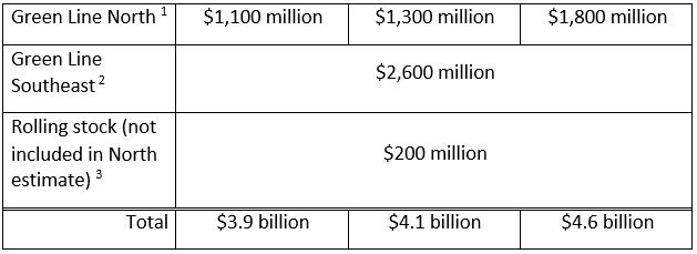
1
Range of estimates depends on vertical alignment through Bow River and downtown (24 Avenue N to 10 Avenue S); details on options to connect to the downtown in TT2015-0149 North Central LRT Centre City Options Att 1.pdf; does not include rolling stock.
2
Green Line Southeast estimate included rolling stock and initial phase of Bus Rapid Transit implementation as part of the broader program, as outlined in TT2012-0360 Southeast Transitway (SETWAY) Staging Update.
3
Half oflight rail vehicles required for full buildout North Pointe to Seton at $3 million per vehicle; line item required to top up Green Line North estimate, which did not include vehicles.
With that estimate, the Federal Government announced $1.53 billion in funding towards the Green Line LRT, thanks in large parts to the efforts of Calgary MPs Michelle Rempel and Jason Kenney. Thanks to this, we were able to move straight forward with planning an LRT rather than spending money on a BRT SETWAY and then converting it to an LRT in the future. Later that year, the City extended its funding commitment to a 30 year time period, providing a funding mechanism for the City’s one third portion of the Green Line’s cost, now only waiting on the Province. The cover report and full December 2015 Green Line funding, staging and delivery update can be found at their respective links.
After a thorough consultation with Calgarians – both businesses and residents alike, Council approved the recommendation for a fully tunneled route through the downtown core in late 2016. As a result of a shift in what the project was going to look like, compared to when it was first developed (fully at-grade, initial northern alignment along Nose Creek, then along Centre Street), the project’s total cost had also shifted and Council had to discuss stages of the Green Line.
Consultation continued, transit oriented development and station location talks progressed and Stage 1 construction, including a tunnel from 16 th Ave North through downtown and the Beltline, was approved at a total cost of $4.65 billion , as estimated by Administration, in June 2017. The tunnel portion itself had an estimated price tag of $1.95 billion . The following month, the province pledged its share of the project.
We have since received the funding commitments from the other two orders of government and the City Centre alignment continues to be looked at and refined. It now appears that the bored tunnel is unlikely as this could result in downtown stations upwards of 7 stories underground – not exactly accessible transit. The Green Line team is in crunch mode looking at other options and I remain optimistic that we will figure out this alignment over the next three months and the potential cost savings of not digging a deep tunnel could result in a further expansion of the line beyond the Stage 1 alignment.
Where is the Green Line at now, you ask? Currently, the Green Line team has completed its request for qualifications (RFQ) for the light rail vehicles and will move forward on the request for proposals (RFP) in December. The RFQ for the Stage 1 contract , covering Shepard to the Rivers District, was released in August and is progressing along.
***
So there is a fairly condensed history of the planning that had happened prior to us eventually approving the plan for what is now known as the Green Line. The north central line was initially thought to come down Nose Creek. However, this would bypass all of the communities south of Beddington Trail while providing poor connectivity to areas between Beddington and Downtown. After thousands of submissions, hundreds of hours of in-person consultations, and years of work, a Centre Street alignment was determined to best serve the needs of the City, while serving the highest number of people. Instead of what would have essentially been a commuter train for the neighbourhoods north of Beddington Trail, we developed a train that would serve all of the communities in between, inspiring increased densification and transit-oriented development in the communities along Centre Street. This is also in alignment with numerous city-wide policies, including our Mainstreets initiative and would help revitalize Centre Street, particularly north of 16 th Avenue.
We have been planning this project since the 1980s and in earnest since 2013 and we should not lose sight of that. As a reminder, here is why the Green Line must be built, and it needs to connect through the downtown core:
By the time additional stages are completed, the Green Line could be serving upwards of half a million people and a quarter million jobs outside the downtown core. Calgarians need this mobility and we need to deliver it.